


 Back
Back
Overlay Districts
-
AIRPORT SAFETY OVERLAY DISTRICT (ASOD)
The airport safety overlay district is established in recognition of airport related hazards which may endanger lives and property; obstructions which effectively reduce airspace required for aircraft takeoff, landing, and maneuvering which reduce the utility of the Manassas Regional Airport and the public investment therein. This district shall be in addition to and shall overlay all other zoning districts where it is applied so that any parcel of land lying in the airport impact overlay district shall also lie in one or more of the other zoning districts provided for by the Zoning Ordinance. The effect is to create a new district which has the characteristics and limitations of the underlying district, together with the characteristics and limitations of the overlay district.
-
CHESAPEAKE BAY PRESERVATION AREA OVERLAY DISTRICT (RPA)
The Board of County Supervisors has found as fact that the Chesapeake Bay is an important and productive estuary, providing economic and social benefits to the citizens of the Commonwealth of Virginia. The health of the Bay is vital to maintaining the state's economy and the welfare of its citizens. Economic development and water quality protection not only may coexist, they must. The Chesapeake Bay waters have been degraded significantly by point source and non-point source pollution from land uses and development along the shores of the Bay, its tributaries, and other state waters. These lands together, designated by the Board as Resource Protection Areas and Resource Management Areas, comprise the Chesapeake Bay Preservation Areas, in accordance with the requirements of the Chesapeake Bay Preservation Act (VA Code), and need to be protected from destruction and damage in order to protect the quality of water in the Bay and consequently the quality of life in the Commonwealth of Virginia. The intent of the Board and the purpose of the Chesapeake Bay Resource Preservation Area Overlay District is to:-
Protect existing high quality state waters;
-
Restore all other state waters to a condition and/or quality that would permit all reasonable public uses and will support the propagation and growth of all aquatic life, including game fish, which might reasonably be expected to inhabit them;
-
Safeguard the clean waters of the Commonwealth from pollution;
-
Prevent any increase in pollution;
-
Reduce existing pollution;
-
Promote water resource conservation in order to provide for the health, safety, and welfare of the present and future citizens of Prince William County.
-
-
DATA CENTER OPPORTUNITY ZONE OVERLAY DISTRICT (DCOZOD)
[Municode: Section 32-509] [Map]
On August 4, 2015, the Board of County Supervisors adopted Resolution 15-508 to support protection of private property, historical resources and commercial interests from potential negative impacts of new high voltage overhead transmission lines. As part of that resolution, the Board of County Supervisors declared its intent to initiate a zoning text amendment to incorporate appropriate zoning requirements for data centers which would address the infrastructure necessary to support such uses and the potential impacts to other properties. The resolution also noted that this amendment should continue the County's efforts to advance commercial and industrial development. -
DOMESTIC FOWL OVERLAY DISTRICT (DFOD)
[Municode: Section 32-508] [Map]
The purpose of creating a domestic fowl overlay district is to permit the keeping of chickens, pigeons, doves and other domestic fowl on lots with a rural and semi-rural character that also contain a dwelling unit as a principal use. The keeping of domestic fowl is permitted by right on A-1 zoned properties and on SRR zoned properties by Special Use Permit on a lot with or without a principal residence within this district. To ensure reasonable protection of health, safety and welfare associated with the keeping of domestic fowl, development regulations specific to this district are provisioned. The keeping of domestic fowl is not permitted outside of the Domestic Fowl Overlay District, except on A-1 zoned lots of ten (10) acres or larger. -
FLOOD HAZARD OVERLAY DISTRICT
[Municode: Section 32-501]
The Board of County Supervisors has found as fact that the flood hazard areas of the County are subject to periodic inundation which results in the loss of life and/or property, health and safety hazards, disruption of commerce and other governmental services, extraordinary public expenditures for flood protection and relief, and impairment of the tax base. As such, the Board has chosen to delineate this district in accordance with the areas of the County subject to inundation by the 100-year flood (a flood that, on average, is likely to occur once every 100 years). Areas of the County shown to be subject to this flood were found on the basis of the Flood Insurance Study (FIS) for Prince William County (prepared by FEMA, dated Jan. 1, 1995), engineering studies prepared by the U.S. Army Corps of Engineers, the U.S. Soil Conservation Service, and other public and private sources. Visit County Mapper to view the Flood Hazard Overlay District. -
HIGHWAY CORRIDOR OVERLAY DISTRICTS (HCOD)
[Municode: Section 32-503] [Map]
This special overlay district has been put into place by the Board of County Supervisors as a method with which to protect the health, safety, and general welfare of the public by the prevention or reduction in traffic congestion and distracting visual clutter which may result in danger on the public and private streets, as a limitation on certain automobile oriented, fast service, quick turnover uses and related signage, which generate traffic in such amount and in such manner as to present the possibility of increased danger to the motoring public and other impediments to safe travel. This district is created to mitigate adverse impacts resulting from development along major thoroughfares in Prince William County. -
HISTORIC OVERLAY DISTRICT (HOD)
[Municode: Section 32-501] [Map]
A Historic Overlay District is created for the purpose of imposing special requirements in addition to the requirements pertaining to the underlying zoning district in designated areas of the County, in order to protect and perpetuate those areas or structures which have been designated as being of significant historic, architectural, or cultural interest. Regulations imposed in such a district are intended to: 1) protect against destruction of, or encroachment upon such historic resources; 2) encourage uses which will continue to preserve them, and; 3) prevent the creation of adverse environmental influences. Exterior alterations to buildings within the historic overlay district are administered by the Architectural Review Board. -
REDEVELOPMENT OVERLAY DISTRICTS (ROD)
The purpose of creating a Redevelopment Overlay District is to promote and perpetuate the continued economic viability of older commercial neighborhoods which are experiencing economic decline. To achieve this purpose, development regulations specific to the district are provisioned to encourage the redevelopment and the upkeep and upgrade of existing businesses, thereby providing an economic stimulus to the district. Redevelopment overlay districts are established by the Board of County Supervisors on lands in proximity to major thoroughfares which, based on expressed findings of fact by the Board, have all of the following characteristics:-
Area predominantly developed and with few vacant sites;
-
Number of developed parcels exceeding one hundred (100);
-
Developments are predominantly residential;
-
Average age of structures is twenty-five (25) years old or more;
-
Developments lacking compliance with current standards and consequently unable to expand;
-
Area visually unattractive because of the proliferation of nonconforming signs, overhead utility lines, poorly maintained buildings and parking lots, and sparse landscaping;
-
Developments are accessed by numerous and closely spaced driveways connecting to the main highway;
-
Area in need of economic incentives such as grants, public/private partnerships, and special financing programs to prevent its further deterioration.
-
-
TECHNOLOGY OVERLAY DISTRICT (TEOD)
Image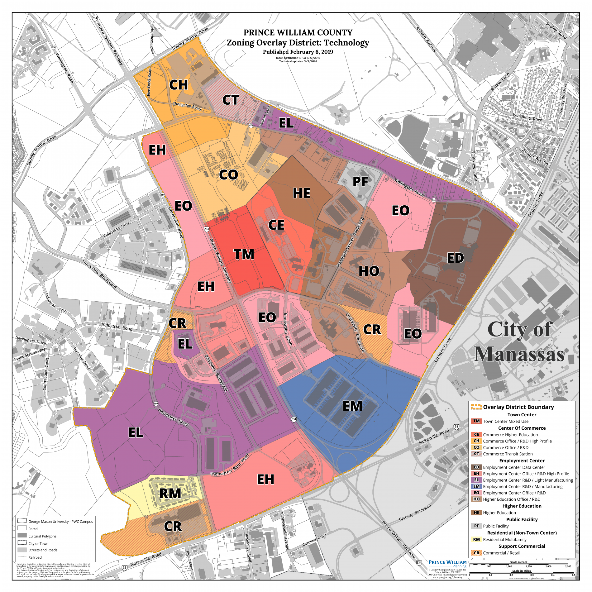
[Municode: Section 32-506] [Map]
The Technology Overlay District (TeOD) is intended to promote harmonious development which is conducive to establishing and maintaining collaborative public-private research partnerships. To achieve this intent, the district will be located adjacent to a major public institution, such as an institute of higher education. The district will primarily promote those nonresidential uses that support and enhance the activities of the major public institution and that respond to the County's targeted industries program. In addition, the district will provide for residential dwelling units for people primarily associated with the targeted industries and the major public institution. The district will also provide for compatible nonresidential service uses needed to support the overall public-private research environment.
The TeOD is specifically intended to provide for primary employment uses consistent with the county's targeted industry program. These primary employment uses include research facilities, offices, prototype production facilities, and other light manufacturing operations that require the continual or recurrent application of advanced research.
Special requirements in addition to or in place of the requirements of an underlying zoning district may be imposed to achieve the desired goals set forth above. Such requirements are intended to promote harmonious development by:-
Ensuring that individual properties are developed so as to preserve existing natural topographical features and wooded areas;
-
Promoting generous landscaping, building and parking lot setbacks;
-
Encouraging innovative site designs which include continuity of architectural and design themes while allowing flexibility;
-
Preventing the creation of or reducing the presence of adverse environmental influences such as noise, traffic, fumes, waste, unsightly views (i.e., outside storage, open off-street parking areas), and excessive lighting and signage;
-
Encouraging development which results in a campus-like setting in developed areas and a park-like setting in preserved open space areas; and,
-
Encouraging non-motorized access between individual properties through the development of a comprehensive sidewalk/trail system.
-
- Email: [email protected]
- Call: (703) 792-3340