


 Back
Back


Cultural Resources: Cemetery Preservation
Mission
To identify, document, and advocate for Prince William County’s cemeteries and burial grounds while encouraging stewardship of the County’s historic cemeteries.
Cemetery Database
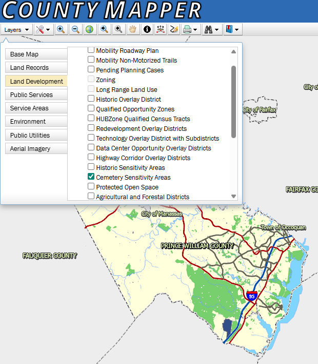
In 2020 the County cemetery database was made public by the Planning Office on County Mapper in an effort to be more transparent regarding cemetery locations. The Cemetery Database was first published as a layer on County Mapper under Land Development.
At the time the layer was known as “Cemetery Preservation Areas” and displayed a 50- foot buffer indicating the subjective location of a cemetery. This data came from the 2001 Historical Commission sponsored inventory known as the Prince William County Cemetery Inventory by Ron Turner, or from citizen reports and archaeological surveys.
The layer was updated over time and in 2025 the database entered its current edition. Now called the “Cemetery Sensitivity Areas”, similar to the Prehistoric and Historic Sensitivity Areas, the layer now consists of three display types:
- Cemetery Sensitivity Area is all reported and relocated cemeteries of which the County has a record. The Sensitivity Area will be displayed as a 50-foot circle on the map in the approximate location of the reported cemetery.
- Cemetery is an area of a cemetery that is separately platted or has been archaeologically delineated as per the County’s Zoning Ordinance 32-250.110.
- Cemetery Preservation Area is a strip of undisturbed land surrounding a cemetery, beginning at the edge of the archaeologically defined limits of burials and graves and extending outward a minimum of 25 feet per Zoning Ordinance 32-250.110
If you know of a cemetery not shown on this database. Please contact Emma Dietrich, the Cemetery Preservation Coordinator of the Planning Office at [email protected] or 703-792-6824
Cemetery Map
Use the below map to engage with the Prince William County Cemeteries Map!
This map is a living dataset with new information and updated locations occurring regularly.
Feature boundaries and locations are not legally recorded documents and do not represent an on-the-ground survey. All boundaries and locations are approximate and are for illustrative purposes only.

Prince William County Cemetery Inventory
The 2001 Historic Commission sponsored cemetery inventory by Ronald Ray Turner
Headstone Recording Form
A standardized form used to record headstone information and the condition of the grave marker.
Works Progress Administration Historical Records Survey
Digitized copy of the Works Progress Administration Historical Records Survey from 1937 for Prince William County. This record includes information on cemeteries and historic sites.Report a Cemetery
To help keep our records up to date, use the below form to report a cemetery, or ensure we have correct information for a local cemetery!

This form is coming soon! In the meantime, if you know of a cemetery, please contact Emma Dietrich, the Cemetery Preservation Coordinator of the Planning Office at [email protected] or 703-792-6824
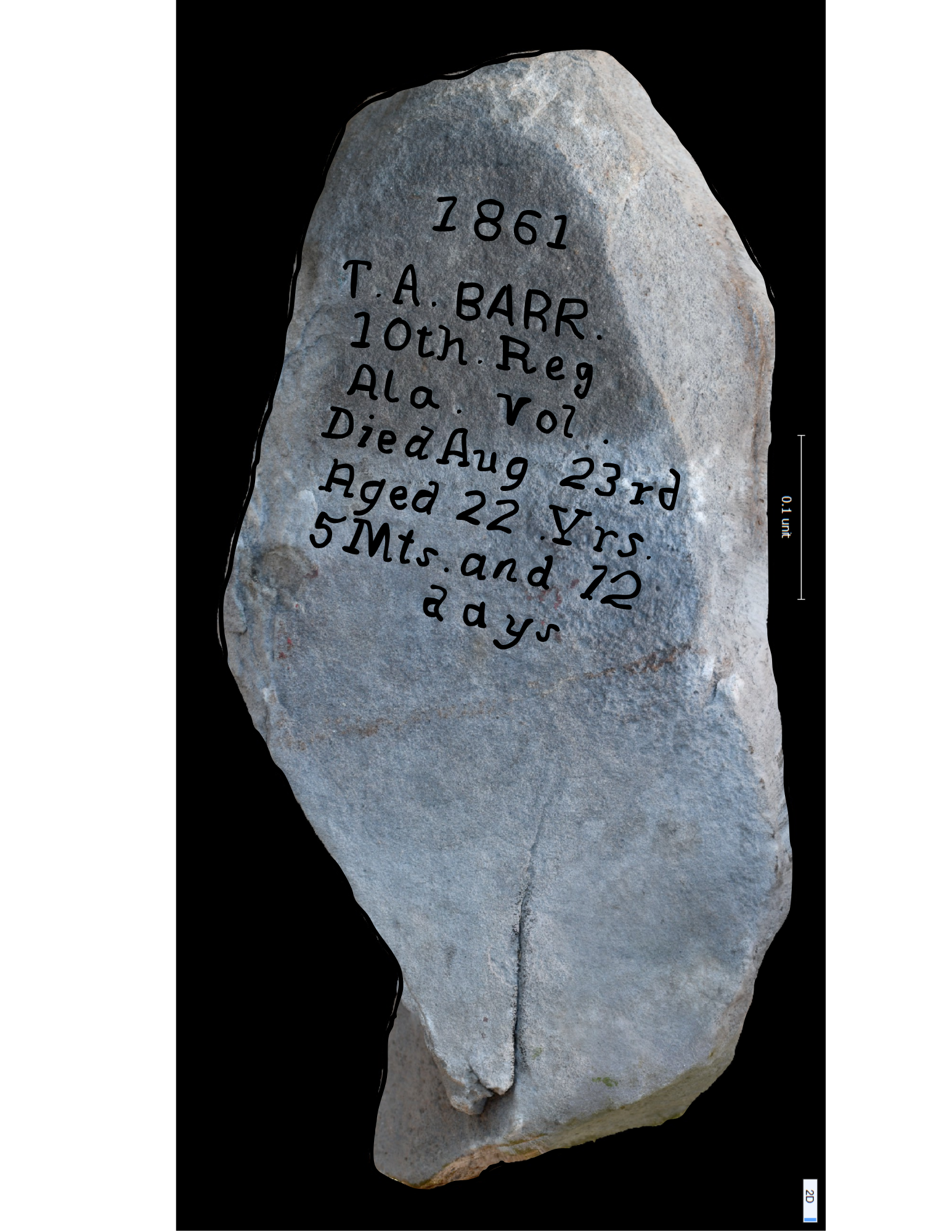
Featured Cemetery
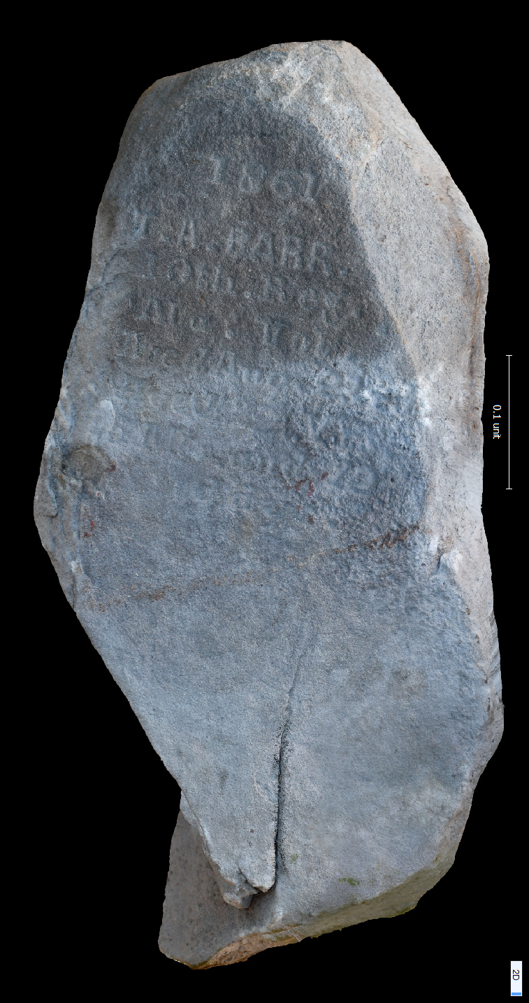
10th Alabama Cemetery, Bristoe Station Battlefield Heritage Park
In the summer of 1861, the 10th Alabama Regiment was camped at Camp Jones near Bristoe Station. Disease was rampant, and the regiment needed to establish a cemetery to bury their dead. At least 82 men were laid to rest in this cemetery with grave markers ranging from wood, fieldstone, and upright tablet markers.
"They had, as the head boards indicated, died during the months of August and September, 1861. The names in some instances had been cut into stone with the name of the company and the time of death of the deceased. And these were Americans. It was a truly a sad scene"- Stephen Durkee, 7th Wisconsin Infantry, April 12, 1862
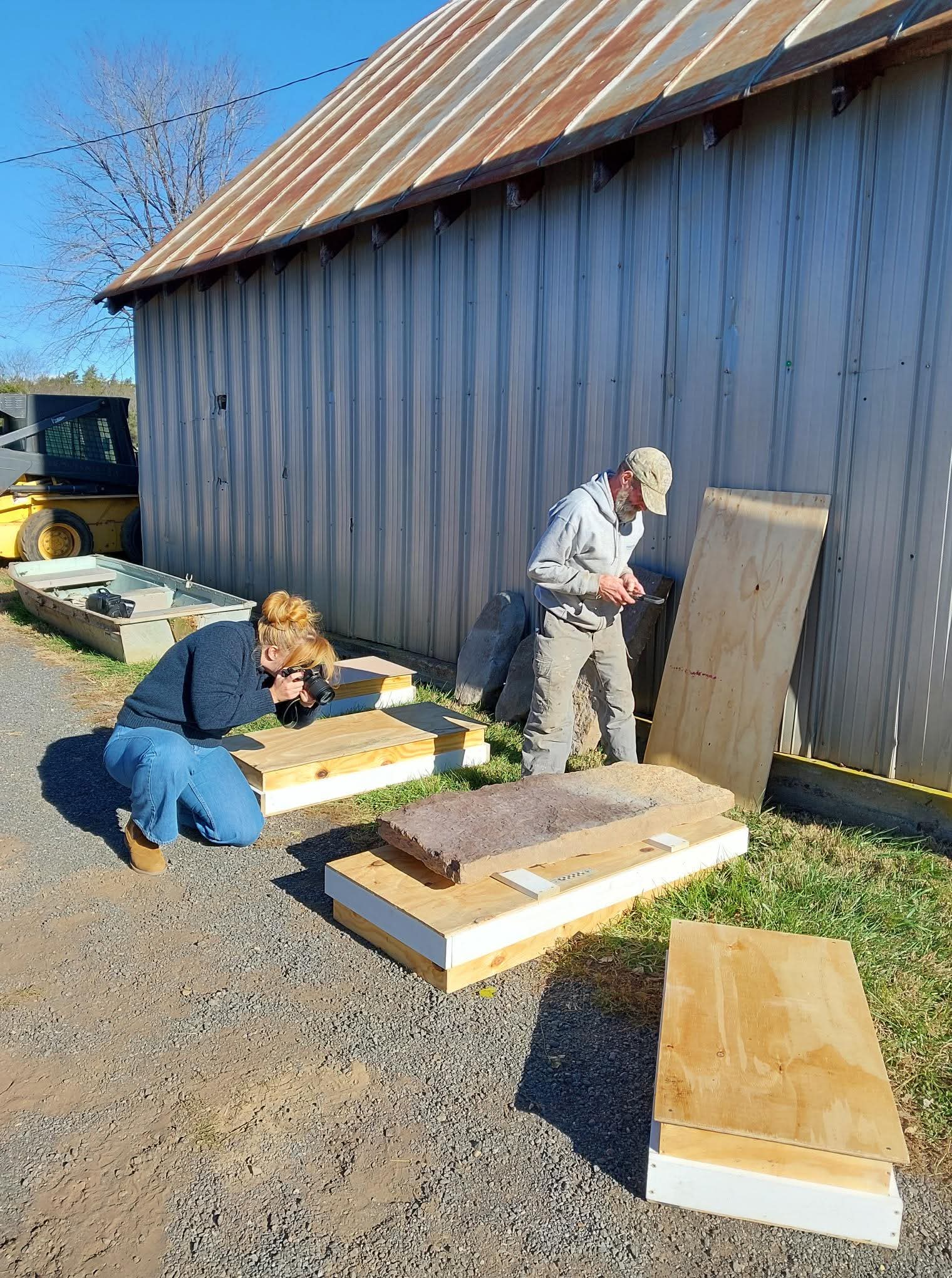
Over time, the wooden makers decayed and were lost, and out of concern for the safety and preservation of the remaining markers, four of the inscribed headstones were removed.
In November of 2025, the headstones were returned to Bristoe Station Battlefield Heritage Park and Planning Staff had the opportunity to assist the Office of Historic Preservation in their retrieval and documentation.
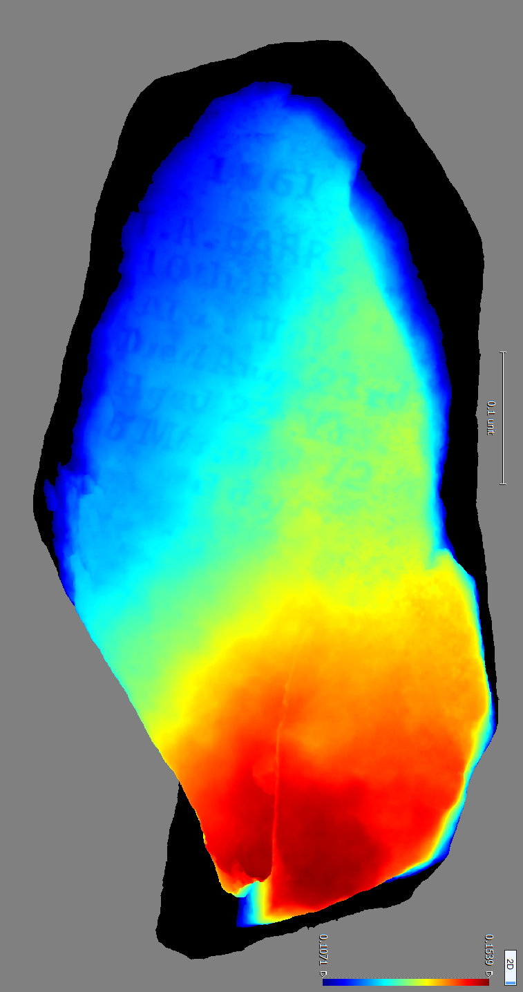
Part of the documentation included photographing the grave markers to create photogrammetric 3D models. This process allows for an in depth digital documentation of the stone which can allow for measurements and further analysis without damaging these historic resources. One such result is the creation of a Digital Surface Model (DSM). DSMs can be used to highlight the inscriptions that may not be visible to the naked eye.
Check back quarterly for the next featured cemetery!


Frequently Asked Questions
Expand all- Where can I find information on a cemetery in Prince William County?
While we work on creating our cemetery records more accessible, please contact Emma Dietrich, the Cemetery Preservation Coordinator of the Planning Office at [email protected] or 703-792-6824.
Please include the cemetery name or cemetery number (alpha numeric code found within the cemetery database), and the address if known.
- I noticed a cemetery is damaged, who do I report this to?
Please report the damaged cemetery to Emma Dietrich, the Cemetery Preservation Coordinator of the Planning Office at [email protected] or 703-792-6824.
If you believe this cemetery was vandalized, please contact local law enforcement.
- What do I do if I find human remains or an unmarked grave?
First and foremost, do not touch, disturb, or remove anything. All on site activity must cease. Disinterring (removing from a grave) or displacing part or all of any buried human remains is a Class 4 felony under Virginia law (§18.2-126). Conviction is punishable by two to ten years in prison and up to $100,000 in fines. This law applies to all human burials, whether prehistoric, historic, or modern. Contact local or state law enforcement immediately.
- I have an old abandoned cemetery on my property. What are my legal rights and obligations? Do I have to maintain the cemetery or let family members come on my land?
As the owner of property that includes a cemetery, you are obligated to not disturb the burials and not damage, desecrate or remove*, gravestones, cemetery fencing, monuments, etc. Virginia law protects all cemeteries from willful and malicious damage, whether by the property owner or by others (§18.2-127). You may maintain the cemetery if you wish or allow descendants or other parties to do so (contact the county Cemetery Preservation Coordinator for recommendations). You are required to allow access to the cemetery for visitation by family members or descendants and others who wish to conduct genealogical research. You are not required to create a special access route if one is not already present.
- What are the legal means for removing and relocating human remains from cemeteries and burial places?
Virginia, human remains can be legally removed from a cemetery or burial place and relocated to another cemetery by obtaining an order from the city or county circuit court (see §57-36, §57-38.1, §57-38.2, and §57-39). In the case of unmarked burials within formally chartered cemeteries that will be recovered by professional archaeologists, both a court order and a permit from the Department of Historic Resources will be necessary (§10.1-2305). Relocation of burials should be considered as a “last resort,” applicable only when the burials or cemetery are endangered or when family or descendants request their relocation.
- Someone else now owns the land where my ancestors are buried. What are my rights to visit that cemetery?
Unless the deed of sale for the property specifies certain conditions of the sale, then most rights go to the new property owner. Virginia law does require that landowners allow access to cemeteries on private property for the purpose of visitation by family members/descendants or plot owners, and for genealogical research. Please contact the landowner to arrange for access including frequency, hours, and duration of access (§57-27.1).
As of 2024, the Code of Virginia has outlined the interment rights for immediate family members and descendants for family cemeteries (§ 57-27.1:1). Please see this law for more detail.
If your property lies adjacent to the property containing your family cemetery, and you feel that the cemetery has fallen into neglect, you may petition the Prince William County Circuit Court for relief, including permission to access the property and maintain the cemetery (§57-39.1).Heirs and descendants may also petition the court for permission to relocate an ancestor’s remains from any abandoned family cemetery, with the same caveat (§57-38.2)
- The property I plan to develop has a cemetery. Are there any requirements for the treatment of the cemetery?
For a site plan or subdivision plan, through County Ordinance (Sec. 32-250.110), a cemetery shall be archaeologically delineated, unless the cemetery boundaries have previously been determined through easement or is separately platted, and the boundary will be shown on the plan. The plan will also provide pedestrian access, identify the party responsible for maintenance and depict the cemetery fence detail. For more details and other requirements, read Sec. 32-250.110 of the Prince William County - Code of Ordinances.
For a rezoning or special use permit application, submission of a completed Cultural Resource Assessment is required. This will outline any submission requirements for all cultural resources including a cemetery. It is recommended that the archaeological delineation of a cemetery be conducted and the report submitted with the rezoning or special use permit application to confirm the size, location, and extent of the cemetery to be shown on the MZP.
Please contact the Cemetery Preservation Coordinator at [email protected] or 703-792-6824.
Note: This information is provided as a service to Prince William County citizens and should not be construed as legal advice. If you have questions about Virginia’s burial laws or your rights as a citizen, we strongly urge you to contact a legal professional.
Questions or comments?
- Email: [email protected]
- Submit the Planning Comment Form
Note that under the Virginia Freedom of Information Act, comments, including any personally identifiable information that is included in the comments, are subject to public inspection.
To receive automatic updates about general county government information, including Planning Office notifications, road closures, tax reminders, and other community information subscribe to PWC Alerts.