


 Back
Back


PW Digital Gateway
On November 1, 2022, the Prince William Board of County Supervisors adopted Comprehensive Plan Amendment #CPA2021-00004 PW Digital Gateway.
Board of County Supervisors Res. No. 22-508
Rezoning applications within the area of PW Digital Gateway Comprehensive Plan Amendment have been submitted. The three rezoning applications are (with a link to each case in ePortal):
-
Rezoning #REZ2022-00032 Digital Gateway North
-
Rezoning #REZ2022-00033 Digital Gateway South
-
Rezoning #REZ2022-00036 Compass Datacenters Prince William County Campus 1 (formerly H & H Capital Acquisitions Digital Gateway)
Questions or comments?
Comments may be provided by submitting a Public Comment Form or Phone: 703-792-7615
Please note that under the Virginia Freedom of Information Act, comments, including any personally identifiable information that is included in the comments, are subject to public inspection.
To receive automatic updates about general county government information, including Planning Office notifications, road closures, tax reminders, and other community information subscribe to PWC Alerts.
The information below on this page regarding the adopted comprehensive plan amendment will not be updated and the web page is being archived.
PROJECT OVERVIEW
Comprehensive Plan Amendment #CPA2021-00004, PW Digital Gateway is a request to create a technology corridor along Pageland Lane for the development of data center uses. The application proposes to utilize existing transmission and fiber optic infrastructure. The corridor, which originally included 27 parcels located on both sides of Pageland Lane in four geographic areas south of Sudley Road and approximately one mile north of Route 29, was expanded to evaluate the entire corridor between Sudley Road and Route 29. Data centers are on the Board’s adopted List of Targeted Industries for New, and Expanding Companies revised on August 4, 2020.
Historical Commission Research on PW Digital Gateway
Presentation on PW Digital Gateway Process and Timelines - October 11, 2022
Frequently Asked Questions (updated March 28, 2022)
Draft Plan - 2nd Version - August 15, 2022
Responses to Questions from July 20, 2022, Planning Commission Work Session
Draft Plan - 1st Version - July 7, 2022
BOARD OF COUNTY SUPERVISORS INITIATION
On July 20, 2021, through Res. No. 21-445, the Prince William Board of County Supervisors initiated an amendment to the Comprehensive Plan for PW Digital Gateway to change the Long Range Land Use from AE, Agricultural or Estate and ER, Environmental Resource to Technology / Flex (T/F) with a T-3 Transect to include related impacts on supporting infrastructure and consider alternative comparable land use designation options that meet the needs of the Applicant and the priorities of the Prince WIlliam Board of County Supervisors. Additionally, the Prince William Board of County Supervisors also approved a friendly amendment to enhance the study area to include the entire corridor between Route 29 and Sudley Road in order to review in a holistic manner (traffic, land use, and environmental concerns), look carefully at the areas directly abutting Conway Robinson Memorial State Forest and the Manassas National Battlefield Park, and coordinate the review with the open space corridor concepts of the rural area (native plant buffering and sustainability) to preserve as much of the area as possible.
RELATED PROJECTS
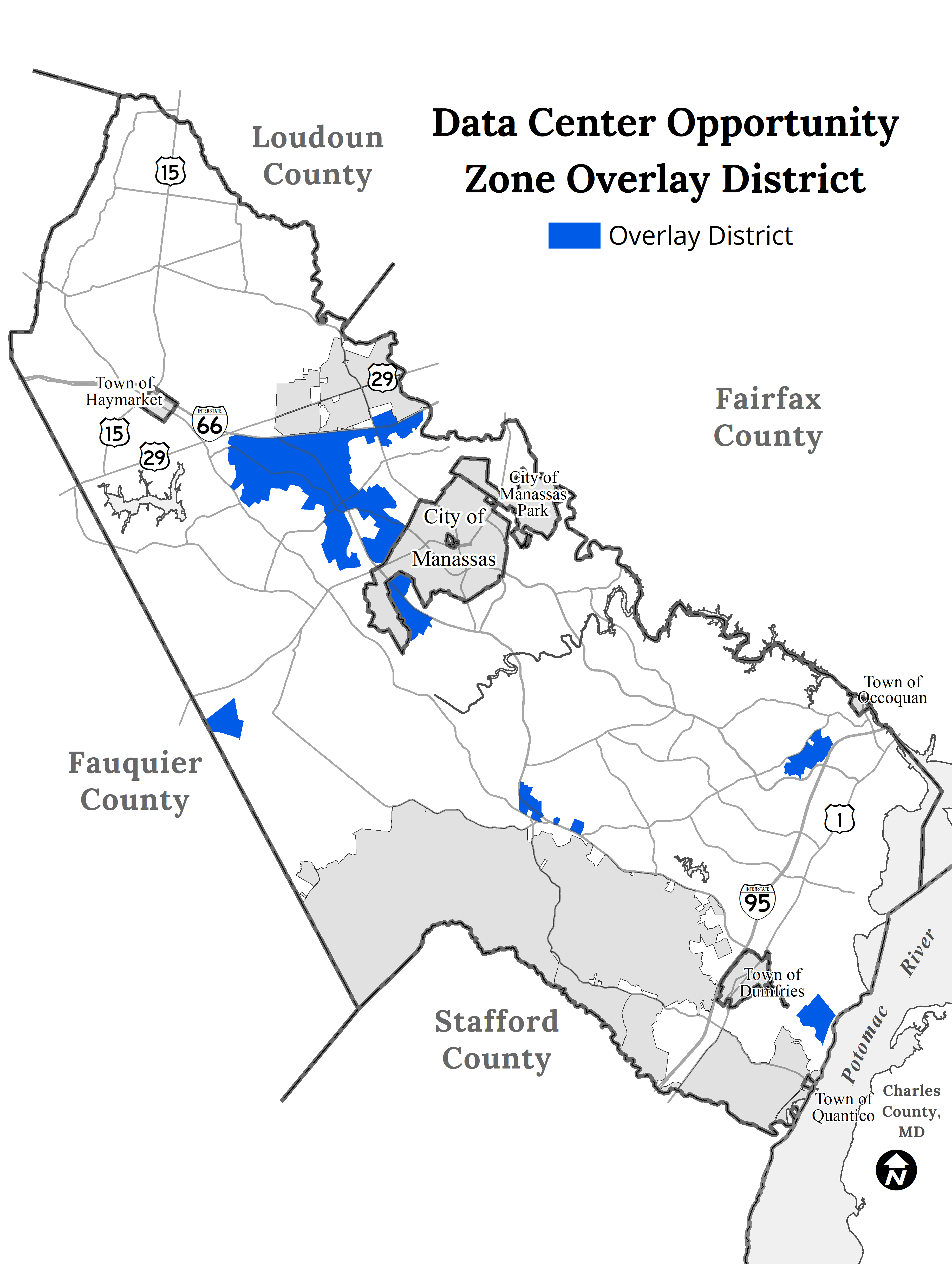
Data Center Opportunity Zone Overlay District Comprehensive Review
The Data Center Opportunity Zone Overlay District (DCOZOD) was created to promote the development of data centers within areas of the County where there is existing infrastructure that could adequately support the proposed use. This District continues the County's efforts to attract and advance high-tech industrial development while limiting negative impacts to neighboring communities. Data centers are on the Board’s adopted List of Targeted Industries for New, and Expanding Companies revised on August 4, 2020.
On May 18, 2021, through Res. No. 21-327, the Prince William Board of County Supervisors initiated amendments to County policies and regulations related to data center development including the Data Center Opportunity Zone Overlay District, the Design and Construction Standards Manual, the Comprehensive Plan, the Zoning Ordinance, and other appropriate development regulations. This project is being processed concurrently with the PW digital Gateway. For more information regarding the Data Center Opportunity Zone Overlay District Comprehensive Review visit the project webpage at: www.pwcva.gov/datacenteroverlay.
Scope Differences for Data Center Projects
As research documents related to data center development become readily available as part of the Data Center Opportunity Zone Overlay District Comprehensive Review the will be posted here in addition to the project webpage:
Other related documents:
- Economic Development - Data Center Market Viability Review as of May 27, 2021
- Public Works - Memo to the BOCS: Groundwater Study Proposal - November 22, 2021
- Public Works - Memo to the BOCS: Update on Evaluation of the Occoquan Watershed and Reservoir Protection Overlay District - November 22, 2021
- Camoin - Targeted Industry Land Need Analysis - May 13, 2022
- The Department of Economic Development contracted Camoin Associates to prepare a land needs analysis for all Targeted Industries in Prince William County for the next 20 years based on industry projections and past performance. The analysis estimates the aggregated amount of land for all of the Targeted Industries and compares that with the Planning Office's Build Out Analysis to identify any gaps for additional land that may be needed to support the growth of these industries and increase the County's overall commercial tax base. This analysis is important as it will help inform the Land Use Chapter update of the Comprehensive Plan as well as the Data Center Overlay Comprehensive Review, and pending Comprehensive Plan Amendment (CPA) request, including the PW Digital Gateway CPA.
- Analysis of the Occoquan Watershed - April 15, 2021
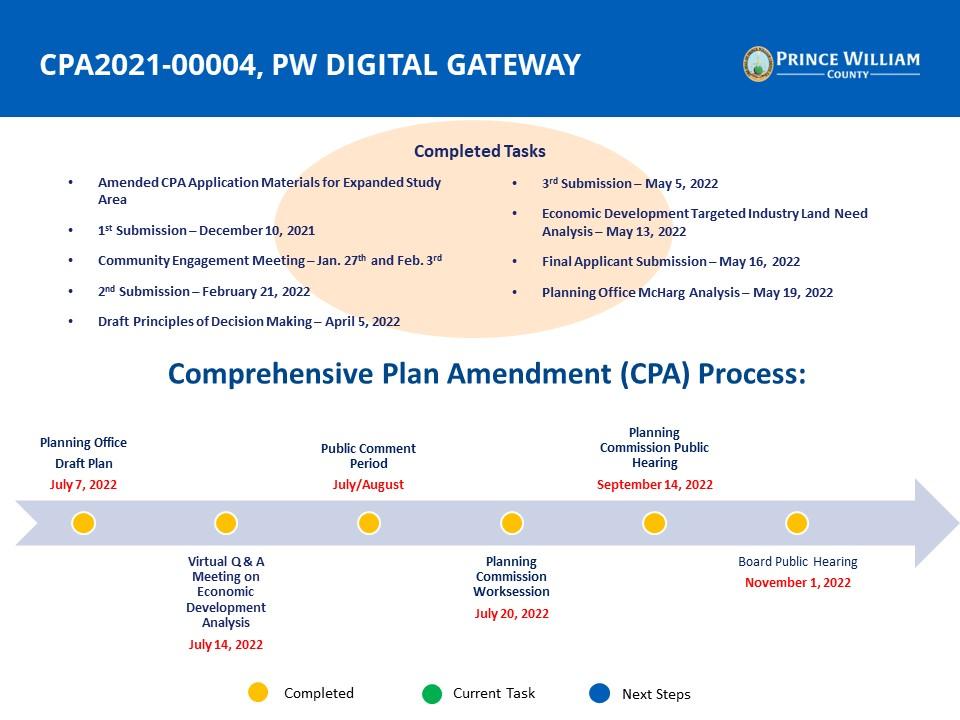
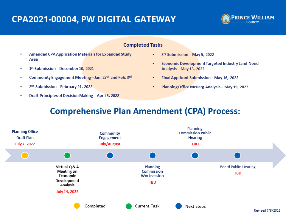
PROJECT TASKS
This project has been broken down into multiple tasks and will be processed concurrently with the Data Center Opportunity Zone Overlay District Comprehensive Review and the completed 2040 Comprehensive Plan update. These tasks include establishing the boundary for the expanded study area, submission and review of the Comprehensive Plan Amendment application, and public hearings to consider adoption of the Comprehensive Plan Amendment (CPA) through the public hearing process. These tasks build off of each other and help to inform the next steps in this project. A community meeting will be held during the CPA submission and review but opportunities to provide public input are available during all tasks of this project.
Task 1: Establish an Expanded Study Area Boundary (Complete)
Produce and publish a detailed map of the study area to establish the area of review.
Task 2: CPA Submission and Review (Ongoing)
Submission of the CPA application incorporating the expanded study area boundary.
Review of the request by county staff and relevant Boards, Committees, and Commissions to provide comments on the request.
Additional submissions as needed to address comments.
Task 3: Community Engagement (Ongoing)
Community meetings were held to discuss the proposal and receive community feedback (completed).
Final submission of the application.
Task 4: Public Hearing Process
Planning Staff analysis and recommendation
PC Work Session: July 20,2022
PC Hearing: September 14, 2022
BOCS Public Hearing: November 1, 2022
Tasks
Expand all- Task 1: Establish an Expanded Study Area Boundary
Define Criteria for Establishing a Study Area
The Board of County Supervisors' initiated the CPA with an expanded study area Res 21-445 to include the corridor between Route 29 and Route 234. In order to establish the boundary of this study area staff developed five criteria for consideration of inclusion:
- Original PW Digital Gateway application
- Board directed expansion to include US Route 29 through VA Route 234
- Property owner expressed interest
- Established communities
- Existing cultural and environmental resources
The above criteria are intended to define the study area boundary. Establishment of the study area is only intended to define the area of review. Recommendations for areas within the boundary will be made during the CPA review process.
Proposed Study Area
Image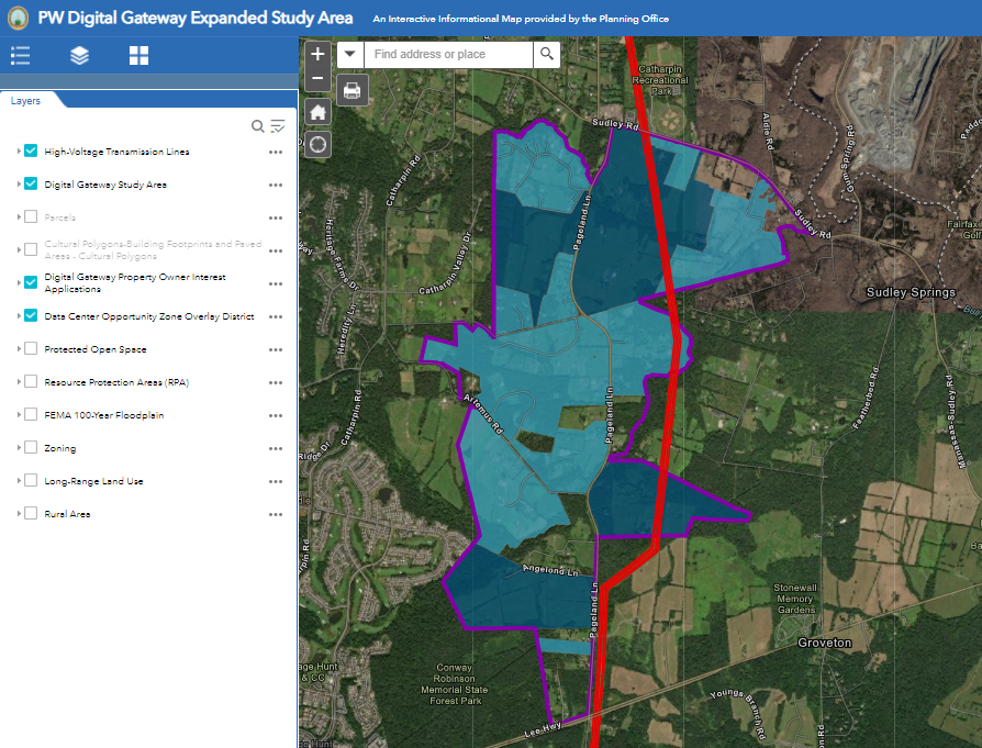
In consideration of the five criteria established above an expanded study area boundary has been defined. The proposed study area consist of 194 parcels and 2,139 acres between Route 234 and Route 29. An Interactive Map has been posted to allow for a detailed review of the study area. Additionally, the Planning Office has received a number of request from property owners requesting inclusion in the study area.
- Task 2: CPA Application Submission and Review
CPA Application Submission
Following initiation of Comprehensive Plan Amendment applications additional materials are required as outlined in the Comprehensive Plan Amendments Application Package including:
- Area Characteristics
- Comprehensive Plan Analysis
- Description of Environmental Resources
- Comprehensive Plan Policy guidance
- Other Information as needed
In order to help facilitate submission materials County Staff and the Applicant established a project team. The project team has met to discuss CPA submission requirements and the expanded study area on:
- August 27, 2021 - Meeting to discuss the Board's initiation of an expanded study area, the application process and required materials with available County agencies.
- August 31, 2021 - Meeting to discuss the Board's initiation of an expanded study area, the application process and required materials with available County agencies, including agencies that could not previously be in attendance.
- September 7, 2021 - Meeting to discuss/finalize input for the expanded study area boundary, the application process and required materials.
- September 22, 2021 - Meeting to discuss the application process, required materials, and potential timeline.
- October 6, 2021 - Meeting to discuss submission requirements and finalize process timeline.
- October 21, 2021 - Meeting to discuss upcoming submission.
- November 4, 2021 - Meeting to discuss November 4, 2021 application submission.
The first submission application was been submitted for review on November 3, 2021 and accepted on November 10, 2021.
Agency Review
1st Submission - The 1st submission application package was sent out for agency review to county agencies, adjacent jurisdictions, and relevant Boards, Committees and Commissions for review on November 10, 2021. Comments are due on December 10, 2021.
CPA2021-00004, PW Digital Gateway - 1st Submission
1st Submission Comments Report - Revised on 12/15/2021 to include clarification on VDOT comments.
Additional comments received:
- Virginia Department of Forestry
- Loudoun County Planning and Zoning
- Historical Commission Resolution - Approved January 11, 2022.
2nd Submission - The 2nd submission application package was sent out for agency review to county agencies, adjacent jurisdictions, and relevant Boards, Committees and Commissions for review on January 19, 2022. Comments are due on February 21, 2022.
CPA2021-00004, PW Digital Gateway - 2nd Submission
2nd Submission Comments Report - Published February 25, 2022
Additional Comments received:
3rd Submission - The 3rd submission application package was sent out for agency review with comments due on May 5, 2022.
CPA2021-00004, PW Digital Gateway - 3rd Submission
3rd Submission Comment Report - Published May 25, 2022
4th Submission - The 4th submission application package was submitted to the Planning Office on May 16, 2022.
CPA2021-00004, PW Digital Gateway - 4th Submission
Applicant Response to Planning Commission Questions - August 9, 2022
Comments from government agencies and departments - August/September 2022
5th Submission - The 5th Submission was submitted to the Planning Office on September 19, 2022
CPA2021-00004, PW Digital Gateway - 5th Submission
Planning Office Analysis:
A McHarg analysis is being conducted by the Planning Office to better understand constraints within the study area and ultimately develop a staff recommendation on the CPA. The spatial analysis model is currently being developed by the Planning Office and our Department of Information Technology.
- PW Digital Gateway Data Analysis Map - An interactive map with the layers Staff has identified as important in the development of the land analysis and Staff's recommendation for the study area.
A targeted industry land use study is currently being conducted by a consultant to identify how much land is needed for targeted industries throughout the County over the next 20 years. While the study is not specific to PW Digital Gateway, some of the findings may be relevant to PW Digital Gateway, because data centers are one of the targeted industries being studied.
- Camoin - Targeted Industry Land Need Analysis - May 13, 2022
- The Department of Economic Development contracted Camoin Associates to prepare a land needs analysis for all Targeted Industries in Prince William County for the next 20 years based on industry projections and past performance. The analysis estimates the aggregated amount of land for all of the Targeted Industries and compares that with the Planning Office's Build Out Analysis to identify any gaps for additional land that may be needed to support the growth of these industries and increase the County's overall commercial tax base. This analysis is important as it will help inform the Land Use Chapter update of the Comprehensive Plan as well as the Data Center Overlay Comprehensive Review, and pending Comprehensive Plan Amendment (CPA) request, including the PW Digital Gateway CPA.
A data center fiscal impact analysis is currently being conducted by a consultant and our Finance Department. As part of that analysis the consultant will be providing an average real and personal property tax revenue generated, net of cost to government, for a typical 250,000 square foot data center. This should be helpful to understand the fiscal impacts of PW Digital Gateway, and other data center projects.
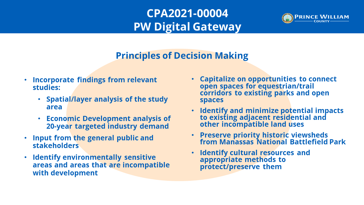
Planning Office Recommendation:
The Planning Office established the PW Digital Gateway Principles of Decision Making criteria to outline the key principles staff incorporated into the draft Plan. The draft plan includes policies, action strategies, and maps which if adopted will be a supplement to the Comprehensive Plan and provide a guidance for future development within the Study Area.
- Task 3: Community Engagement
Completed Engagement:
Community Meeting - January 27, 2022 & February 3, 2022
The Planning Office hosted an in-person community meeting on the PW Digital Gateway Comprehensive Plan Amendment on Thursday, January 27, 2022, at the Beacon Hall Conference Center on the George Mason University SciTech Campus in Manassas. The open house began at 6:00 PM and was followed by in person public comment time after 7:00 PM. Due to a large number of speakers registered for the January 27, 2022, community meeting, a continuation (virtual only) meeting was scheduled for February 3, 2022. This meeting was planned to allow for virtual public comment for those who signed up to participate virtually prior to January 27, 2022, and had not provided in-person public comment.
Watch the PW Digital Gateway in-person community meeting Here. Materials available at the open house are provided in the table below.
Watch the PW Digital Gateway virtual continuation meeting Here.
PW Digital Gateway Open House Meeting Stations
Applicant Planning Mobility
Environmental Resources
PWC Watershed Management
Virginia Department of Forestry
Cultural Resources
Infrastructure
Service Authority
Dominion Energy/NOVEC
Economic Development
Digital Gateway Applicant Boards
Digital Gateway Applicant Exhibits
Digital Gateway Applicant Aerials 1-3
Digital Gateway Cultural Resources Map
Economic Development Handou -
January 27, 2022 Meeting Speaker Registration List (In-person event)
-
February 3, 2022, Virtual Meeting Speaker Registration List (Virtual event)
Future Engagement:
More information related to future engagement opportunities will be updated below when more information is available:
Targeted Industry Land Needs Analysis Virtual Q&A and Public Information Meeting: July 14, 2022 (Zoom)
- For more information and to register for this event please visit the Targeted Industry Land Needs Analysis project page.
-
- Task 4: Hearing Process
Final Draft Document and Staff Recommendation
Staff will revise the draft plan based on feedback from the Planning Commission Work Session and community input.
Planning Commission Work Session - July 20, 2022
Planning Commission Public Hearing - September 14, 2022
Public Hearing before the Prince William County Planning Commission.
PW Digital Gateway Applicant Letter - September 9, 2022
Planning Commission Questions and Responses - September 13, 2022
Board of County Supervisors Public Hearing - November 1, 2022
Public Hearing before the Prince William Board of County Supervisors.