


 Back
Back


Sudley Road Redevelopment Corridor: A ULI Technical Assistance Panel Project
On March 5th and 6th, 2025, Urban Land Institute Washington (ULI) assembled a Technical Assistance Panel (TAP) to identify strategies to transform the Sudley Road corridor into a thriving mixed-use area to serve as an attractive gateway into Prince William County and a destination itself. The Prince William County Planning Office and the Department of Economic Development and Tourism, with support from the Metropolitan Washington Council of Governments (MWCOG), sponsored the panel.
Panelists presented their findings and recommendations organized into four issue areas:
- Community Identity
- Redevelopment and Placemaking
- Mobility and Transportation
- Healthy Living/Well-Being.
ULI Washington Sudley Road TAP Report
Background
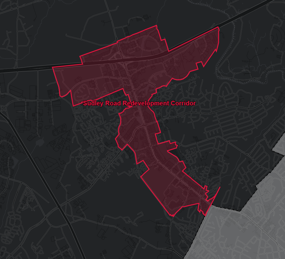
The Prince William County 2040 Comprehensive Plan designated a portion of the Sudley Road area as a Redevelopment Corridor consisting of 1,326 acres and approximately 2.87 miles long. The corridor, located directly off I-66, is a major county gateway and connects the area to the region. The subject area is generally bounded by Manassas National Battlefield Park (North); Ashton Avenue (West); Godwin Drive (South) and a portion of Williamson Boulevard (East). According to the 2040 Comprehensive Plan, redevelopment corridors are geographic areas consisting of older commercial neighborhoods that lack full economic potential and are identified as a priority by the elected Magisterial District Supervisor. This Technical Assistance Program (TAP) will lay the groundwork for developing a future small area plan for the Sudley Road Redevelopment Corridor.
About The Urban Land Institute
The Urban Land Institute Washington (ULI) is a non-profit organization and is the oldest and largest global network of cross-disciplinary real estate and land use experts in the world, from private enterprise to public service. The mission of ULI is to "shape the future of the built environment worldwide" and is committed to connecting active, passionate, diverse members through the foremost global network of interdisciplinary professions; inspiring best practices for equitable and sustainable land use through content, education, convening, mentoring and knowledge sharing; and, to lead in solving community and real estate challenges through applied collective global experience and philanthropic engagement.
About the Metropolitan Washington Council of Governments
Metropolitan Washington is home to nearly 6 million people and is considered one of the nation's largest economies. The region is forecast to add 1.5 million people and 1 million jobs between 2020 and 2050. Managing this growth - and enhancing the region's quality of life - requires regional partnerships. The Metropolitan Washington Council of Governments (MWCOG) regularly brings regional leaders together to develop solutions to major challenges in the area. MWCOG prepares plans enabling the region to receive federal funding, provides members with research and data to inform decision-making, and offers a wide range of programs, including commuter services, cooperative purchasing, technical assistance programs, grants, and public outreach campaigns.
About the Technical Assistance Program (TAP)

Urban Land Institute Washington (ULI Washington) and the Metropolitan Washington Council of Governments (MWCOG) partnered to offer a technical assistance program in the Metropolitan Washington region through the ULI-MWCOG Technical Assistance Program. Eight to ten (8-10) experts work over a concentrated timeline to evaluate and provide market-based feedback on a local development or land use challenge. Panelists are selected from over 2,300 ULI members in the Washington District Council based on the specific nature of each panel assignment.
Panel member expertise typically includes land developers, property owners and managers, investors, designers, planners, engineers, market and financial analysts, as well as members of the general public. The panel meets over 2 days, with a report of recommendations completed thereafter. With the partnership, ULI Washington and MWCOG then deliver three TAPs focused on identifying impetus strategies to magnify the impacts of investments in MWCOG-Designated Equity Emphasis Areas, High-Capacity Transit Station Areas and Activity Centers.
The Sudley Road ULI Technical Assistance Program Application
Expand all- The Assignment
More and more, public policy makers are connecting health with community development strategies. Active transportation planning or identifying food deserts in Comprehensive Plans are two examples. In 2017, Virginia health experts mapped areas in Northern Virginia with high poverty rates, significant social health needs and were able to connect these areas with high premature death rates. The report concluded that health and life span are determined by a broad set of domains, based on economic resources, housing and transportation which could be recalibrated by public and private actions.
In Prince William County, the Sudley Road area, a typical 1970’s auto-centric development, has been identified by healthcare and regional policymakers as having poor community health determinants concentrated in one area. Today, county leaders seek to prioritize investments that will improve housing, transportation and equity that will literally give life to its residents and better economic opportunities.
Overarching Goals for Redevelopment
The County envisions Sudley Road as a vibrant, mixed-use corridor that serves as an attractive gateway into Prince William County. The redevelopment efforts are guided by five key themes:
- Capitalize on Public and Private Redevelopment: Leverage incentives and partnerships to attract investment, creating opportunities that prioritize equity and enhance the economic viability of residents and businesses.
- Improve Connectivity: Build infrastructure that promotes walkability, biking, and transit, fostering seamless links between commercial hubs and surrounding neighborhoods.
- Prioritize Equity: Address social determinants of health and economic opportunity, ensuring redevelopment benefits underserved populations and promotes community pride.
- Explore Market Potential: Assess market trends to reallocate resources effectively, reducing retail oversupply while meeting unmet demand in areas such as nightlife, specialty foods, and sustainable shopping options.
- Learn from Exemplars: Apply best practices from successful redevelopment projects in the Metro Washington area, focusing on urban design, equity, and sustainability.
The redevelopment of Sudley Road represents a transformative opportunity to create a dynamic, equitable, and sustainable corridor. By engaging with community members, businesses, and policymakers, the County seeks to transform this area into a thriving gateway that reflects the values and aspirations of Prince William County. Your input, participation, and collaboration are essential to achieving this vision.
- The ULI Technical Assistance Program
Five Questions
The Sudley Road application, co-developed by the Prince William County Planning Office and the Department of Economic Development and Tourism, identified five questions to be answered by the panel.
- How can the County and property owners best capitalize on public and private redevelopment to increase both community equity and economic viability for residents and businesses and further promote community pride and placemaking?
- What are strategies to make this auto-centric corridor more pedestrian and transit friendly and to improve connectivity between the corridor and adjacent neighborhoods?
- What should the County and community prioritize first in order to promote equity?
- What is the market potential for development of the corridor and what mix?
- What are prime redevelopment projects/initiatives in Metropolitan Washington that would serve as good examples for the Sudley Corridor in Prince William County?
To accurately paint a picture, the application focused on equity, economic development and land planning.
Equity Emphasis Area (EEA)
The "Getting Ahead: The Uneven Opportunity Landscape in Northern Virginia" report published in November 2017 by the Virginia Commonwealth University Center on Society and Health and the Northern Virginia Health Foundation identified the Sudley Road area as an "island of disadvantage" with high poverty rates, low education levels, low income, and other social needs. The report concluded health and life span are determined by a broad set of domains, based on economic resources, housing and transportation. In a 2018 follow up report published by the VCU Center on Society and Health and the MWCOG Health Officials Committee, "Uneven Opportunities: How Conditions for Wellness Vary Across the Metropolitan Washington Region" the authors connected these domains to expected lifespans by establishing the "Metropolitan Washington Healthy Places Index" (HPI). The HPI is a snapshot of census tract conditions associated with life expectancy. In November 2023, the VCU Center on Society and Health and the Northern Virginia Health Foundation published "Lost Opportunities: The Persistence of Disadvantaged Neighborhoods in Northern Virginia" which found that the geographic footprint of the Sudley Road-Bull Run "island of disadvantage" expanded, suggesting immediate action is needed. In response, the Prince William County 2040 Comprehensive Plan targets this corridor for redevelopment and the County is has adopted a new affordable housing ordinance to support the corridor.
Image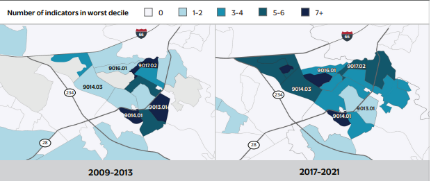
Figure 4. Numbers of indicators in bottom decile in Manassas, 2009-2013 vs 2017-2021.
Regional Activity Center
Although currently under-performing, the Sudley Road area remains one of the County's largest retail corridors offering over 2.8 million square feet of leasable retail space. In July 2002, MWCOG published the "Metropolitan Washington Regional Activity Centers: A Tool for Linking Land Use and Transportation Planning" and in April 2007 the "Metropolitan Washington: Regional Activity Centers and Clusters", where the corridor was identified by MWCOG as a Regional Activity Center and was expected to accommodate the majority of the future growth in the region. However, MWCOG removed the "Bull Run-Sudley Area" Regional Activity Center designation in a January 13, 2013 updated map. A 2021 economic development study indicated this area suffers from retail oversupply for areas within the 1-, 3- and 5-mile radius. Further, five shopping centers that contain 1.7 million square feet of space, are in need of major reinvestment, including Manassas Mall.
In the 2002 report, MWCOG identified Manassas National Battlefield Park, Manassas Mall, and Northern Virginia Community College as Regional Special Attractors due to high trip levels related to economic activity. The owners of Manassas Mall recently submitted a rezoning request to redevelop the site, including 1,041 new housing units and an additional 43,800 square feet of retail. The County Comprehensive Plan identifies this site as a catalyst to future corridor redevelopment and the Planning Office and the Department of Economic Development and Tourism are partnering with the mall owners to support successful redevelopment.
High Capacity Transit
Compared to other COG Equity Emphasis Areas (EEAs) public transportation commuter use is almost non-existent along Sudley Road. While an average of 18.37% of EEA residents commute by public transportation, only 1.4% of Sudley Road corridor commuters rely on the current system. Significant commuter bus service travel along Sudley Road connecting residents to other multimodal and commuter bus services found within the corridor. Although the MWCOG Regional Activity Centers Map does not identify Sudley Road as a High Capacity Transit Area, the 2040 Comprehensive Plan designated Sudley Road for future high capacity transit. This designation is supported by three county and city transportation projects. The County is managing a fully funded, $20 million SMARTSCALE project to improve operational safety and accessibility on Sudley Road between Battleview Parkway and Godwin Drive. The City of Manassas is managing a project to add 1.2 miles of a third northbound lane and sidewalk as well as a new roundabout at the intersection of Sudley Road and Centreville Road (VA-28) is currently under design.
- The March 2025 Sudley Road Technical Assistance Panel Event
In early March 2025, the ULI convened the Sudley Road Tap Team. On March 6, 2025, the TAP team presented preliminary findings in a Sudley Road: Technical Assistance Panel - Presentation of Recommendations presentation.
Existing Plans and Studies
Expand all- County Planning Efforts
Summary of Prior County Efforts
Prince William County has laid a strong foundation for the redevelopment of the Sudley Road corridor through targeted planning efforts.
- Strategic Plan (2021-2024): The County Strategic Plan identifies health, economic resilience, and sustainable growth as core objectives, emphasizing equity in all redevelopment activities. This aligns with the County’s vision of fostering healthy, inclusive, and vibrant communities.
- Sudley Road Designation as a Redevelopment Corridor: Recognizing the area's potential and challenges, the County designated Sudley Road as a "Redevelopment Corridor" in the 2040 Comprehensive Plan. This label highlights its status as a priority area for investment and planning to reinvigorate older commercial neighborhoods and catalyze economic growth.
- Prince William County 2040 Comprehensive Plan: Approved in December 2022, the 2040 Comprehensive Plan incorporates smart growth strategies, equitable development, and sustainability into the land use framework for Sudley Road. It envisions mixed-use development that supports walkability, accessibility, and livability.
- Supporting Studies: Acknowledging the various facets of redevelopment, background studies were conducted to better understand the County's economic offerings. Supplementary market analysis was conducted, such as the Grocery Store Market Study, which assessed grocery store inventory, food accessibility, brand and quality diversity as well as community needs; Retail Inventory Analysis Prince William County, VA - October 6, 2023 by RCLCO Study, which quantified and qualified the retail industry in the County; and the Camoin Land Use/Targeted Industry Study, which provided guidance on land use allocations for key growth sectors such as healthcare, technology, and logistics.
- County Land Use Planning
Description of the Study Area
Location and boundaries: The study area consists of approximately 4,453 acres and is about 2.87 miles long. The area is generally bound by Manassas National Battlefield Park (north), Ashton Avenue (west), Godwin Drive (south), and a portion of Williamson Boulevard (east).
For statistical reasons, the boundaries generally follow 2020 US Census Block Groups. Since it is primarily commercial retail or institutional, area boundaries north of I-66 were based on the Traffic Analysis Zone. This may change as Parkridge Shopping Center, a power center consisting of about 333,135 square feet, was recently rezoned to allow up to 363 planned mixed residential dwelling units (multi-family and single family attached).Land Uses and Maps: The Sudley Road Corridor is mostly developed and includes a range of land uses. The top two existing zoning districts include both Agricultural, A-1, and General Business, B-1. Top residential densities include R-4 and R-16.
Sudley Road Area Planning
A majority of the study area includes the Sudley Road Redevelopment Corridor. Redevelopment Corridors are geographic areas consisting of older commercial neighborhoods which aren’t experiencing full economic potential. Corridors are identified as a priority for planning and investment strategies that serve as a catalyst to promote and perpetuate economic viability. In particular, the area around the Manassas Mall is recommended as T-5 or T-6 and encourages infill higher intensity mixed use development. The Vision for the redevelopment corridor is “Leveraging the many cultural, historic, and natural resources surrounding it, Sudley Road will evolve into a mixed-use corridor offering new housing options, neighborhood-serving commercial uses, and hospitality amenities in a compact, pedestrian-oriented form. The corridor will serve as an attractive gateway into the County from Manassas National Battlefield Park and City of Manassas.”
Summary of Sudley Road Redevelopment Corridor Policies and Action Strategies
Land Use Policy
SRLU POLICY 1: Encourage the redevelopment of older strip commercial uses with a compact mix of uses that integrates new housing options and neighborhood-serving commercial uses. Prioritize the redevelopment of the Manassas Mall site as a catalyst for further redevelopment of the corridor.
Action Strategies
- SRLU 1.1 Complement the adjacent Manassas National Battlefield Park (“Park”) and the Northern Virginia Community College campus with hotels, dining and retail, family-oriented entertainment uses, and other visitor amenities at the northeastern portion of the corridor, adjacent to Interstate 66. Strategically limit building heights, including rooftop mechanicals, adjacent to Manassas National Battlefield Park to prevent visual impacts to the viewsheds.
- SRLU 1.2 Protect the integrity of Manassas National Battlefield Park by encouraging compatible development along its borders. Encourage use of the building design guidelines found in the Data Center Opportunity Zone Overlay District which limits height and visibility from the Park, while minimizing light intrusion into the Park. Incorporate landscape buffers, appropriate trees, facade colors that blend into the landscape (brown and green preferred), and other measures to mitigate visual impact on the Park.
- SRLU 1.3 Through infill residential development, foster a sensitive transition in scale and intensity between Sudley Road and surrounding residential uses.
- SRLU 1.4 Integrate open space and community gathering spaces as part of redevelopment, on undeveloped or underutilized land, and along stream corridors, in order to provide community amenities where appropriate and consistent with applicable law.
- SRLU 1.5 Explore opportunities to create welcoming and identifiable gateways from the City of Manassas and Manassas National Battlefield Park. Pursue gateway strategies such as streetscape and median enhancements, signage, public art, and landscaping. Honor the historical significance of the Park through landscape improvements that foster a transition in character as Sudley Road approaches the Park.
- SRLU 1.6 Accommodate a range of light manufacturing, light industrial and commercial flex, start-up businesses, and office uses, as well as existing and planned data center uses, in designated technology flex areas adjacent to Interstate 66.
- SRLU 1.7 Explore the opportunity of converting the Vulcan Quarry to parks & open space once the quarry has reached the end of its productive use.
Housing Policy
SRHP POLICY 1: Provide a range of housing options along the Sudley Road corridor, including affordable and market-rate options.
Action Strategy
- SRHP 1.1 Integrate infill residential development, with a range of single-family and multi-family housing options, adjacent to the Sudley Road corridor.
Mobility Policy
SRMP POLICY 1: Improve pedestrian and bicycle connections along and across Sudley Road. Explore opportunities for new and/or enhanced east-west connections, including new and/or enhanced crossings on Sudley Road, and connections to surrounding neighborhoods and parks. Explore the potential for pedestrian refuge areas within the Sudley Road median.
Action Strategies
- SRMP 1.1 Improve the pedestrian environment by enhancing the Sudley Road streetscape, while consolidating curb cuts.
- SRMP 1.2 Integrate new street connections as commercial sites redevelop to create a connected street grid.
- SRMP 1.3 Connect the Sudley Road Corridor to existing and proposed trails, with connections to existing natural resource areas and cultural resources.
- SRMP 1.4 Improve pedestrian connections to Manassas National Battlefield Park from the area south of Interstate 66.
- Economic Development in Sudley Road
Countywide Study
The Sudley Road area is a regional commercial draw for Prince William County. There are several studies that evaluate the current demands in the context of the entire county.
- Targeted Industry Land Need Analysis: In 1999, the Board of County Supervisors adopted several "targeted industries" to focus the County's economic development programs and efforts. In January 2022, the County contracted with Camoin Associates to determine the past performance of targeted industries, provide future industry projections, and compare that with available zoned and planned commercial land to determine the pipeline of suitable land for economic development purposes for the next 20 years. The six targeted industry sectors include: Advanced Manufacturing; Federal Government Contracting; Healthcare; Information Communications Technology; Life Sciences and Logistics.
- Prince William County Grocery Store Market Study: The Prince William County Department of Economic Development & Tourism hired S. Patz & Associates to provide a comprehensive market study to identify grocery store needs and opportunities in Prince William County as well as to determine if certain geographic areas within the County lack the diversity of grocery stores that have become common in most growing communities. Map G of this study demonstrates that the Sudley Road is well served by grocery stores including Amazon Fresh, Giant, Lidl, Costco, Oh! Market and a Walmart Supercenter.
- The PWC Department of Economic Development & Tourism provides no-cost employment resources and training to Prince William County residents. Economic Development operates the ELEVATE initiative, which provides job training, GED training, paid work experiences, career coaching, and financial coaching.
Existing Economic Development in Sudley Road
The Sudley Road area reached its peak as a regional commercial destination during the 1980’s -1990’s. Today, this type of commercial land assembly, layout and architecture remains the primary development style.
Prince William Sudley Road/I-66 Redevelopment Corridor Market Observations - Sudley Road(Manassas I-66) Redevelopment Corridor Work Session, December 14, 2021 (Nelson\Nygaard; Rhodeside & Harwell, Inc.; RKG Associates, Inc.). The report led in the context of the proposed Redevelopment Study (Planning and Transportation), identified the number of shopping centers, square footage of leasable retail, and retail sales.
Retail Inventory Analysis Prince William County, VA, October 6, 2023 Study (RCLCO) Related to redevelopment potential of commercial areas. Although evaluated at a Countywide lens, the report provides an inventory and summary of the County’s retail market inventory and performance factors and identifies challenges, opportunities, and trends.Federal Activities
With close proximity to the Washington, D.C., Federal government offices, as well as proximity to several military bases, the Sudley Road area is an ideal location for Federal government contracting and offices. In addition, Manassas Battlefield National Park is National Park Service property.
HUBZones Data
The Sudley Road area contains designated Federal HUBZones. The HUBZone program, which is administered by the U.S. Small Business Administration, provides assistance for small companies that operate and employ people in Historically Under-utilized Business Zones, or HUBZones. The program was created as part of the HUBZone Empowerment Act enacted by Congress in 1998.
To qualify for the HUBZone program, a business must meet the following criteria:
- The firm must be a small business based on the North American Industry Classification System for size standards;
- The business must be at least 51% owned and controlled by U.S. citizens, a Community Development Corporation, an agricultural cooperative, or an Indian tribe (including Alaska Native Corporations);
- The firm's principal office (the location where the greatest number of employees perform their work, excluding contract sites) must be in a HUBZone;
- 35% of the firm's total workforce must reside in a HUBZone;
- Full Qualification criteria web page.
On average, about 3,000 entities register for HUBZone certification each year. The primary goal of the program is to create incentives for the U.S. Federal government to contract with businesses that operate and create jobs in communities with statistically proven economic needs.
- Transportation Planning
Accessibility in the Sudley Road Area
Visualize 2045: A Long-Range Transportation Plan for the National Capital Region is a federally mandated long-range transportation plan approved by the National Capital Region Transportation Planning Board in October 2018 and updated in June 2022.
The section of Sudley Road in the corridor is identified as a Principal Arterial roadway in the 2040 Comprehensive Plan Roadway Plan in the Mobility Chapter and consists of six (6) lanes of traffic within 160 feet of right-of-way. One goal of the Sudley Road TAP is to develop strategies to convert this auto-centric roadway to become more pedestrian, bicyclist, and public/mass transit friendly. The panelists were challenged to prioritize strategies that can better connect the commercial sector of the corridor with adjacent neighborhoods through these strategies.
Equity Emphasis Areas (EEA) are a regional planning concept adopted in 2021 by the COG Board of Directors to elevate equity and inform future growth and investment decisions. As of a 2022 update, 364 of the region’s more than 1,300 census tracts are identified as EEAs, meaning they have high concentrations of low-income individuals and/or traditionally disadvantaged racial and ethnic population groups. EEAs were originally developed by the Transportation Planning Board to analyze potential impacts of its long-range transportation plan but have been applied more broadly across disciplines, such as health, housing, and climate, as part of Region United, COG's Metropolitan Washington Planning Framework for 2030.
The Financially Constrained Long-Range Transportation Plan, or CLRP, identifies and describes all regionally significant transportation projects and programs that are planned in the Washington metropolitan area through the year 2040.
Road Projects
STARS Route 234 Business (Sudley Road) Intersection & Corridor Improvement Study from Battleview Parkway to Godwin Drive (completed 2023): The study evaluated operational and safety conditions to identify potential operational and safety measures in order to improve vehicle throughput, reduce congestion, and increase safety along the corridor. The improvements are to be developed for the purpose of being programmed into the Virginia Department of Transportation’s (VDOT) Six-Year Improvement Program (SYIP).
Route 234 Business (Battleview Parkway to Godwin Drive) Corridor Improvements (PWC): Implements the STARS Project consisting of operational, safety and accessibility improvements on Route 234 Business (Sudley Road) between Battleview Parkway and Godwin Drive. Includes lane re-configuration, signal re-phasing from split phase to 8 phase for some intersections, increasing primary signal heads from two to three, turn lane improvements, access management and pedestrian improvements, including full box high visibility pedestrian crossings and sidewalk. Project includes right-of-way and utility relocation. Fully funded by SMART SCALE. Funds at $20M. Funding became available in 2025 (approximated as a 4-year project).
Sudley Road Third Lane (City of Manassas): The Sudley Road Third Lane project in the City of Manassas is a Capital Improvement Project (T-015) which consists of adding a third northbound lane and completing a sidewalk connection from Grant Avenue in the City northward approximately 1.2 miles to just north of Godwin Drive in Prince William County. The third northbound lane will be created in part by new pavement and the remainder will be created by re-striping an existing right turn lane into a through-turn lane. This roadway section will tie into the existing 3-lane section with a sidewalk that exists in Prince William County. The left turn lane to Godwin Drive will be extended to the south approximately 200 feet. In addition to the roadway widening, the project includes storm drainage. A new curb and gutter along the right lane and associated storm structures will be added. A pedestrian crosswalk and the push-button signal will be added at Rolling Road and at Godwin Drive. Design completed in 2023. Construction contracted awarded April 2024.
Sudley Road/Centreville Road Roundabout (City of Manassas): Proposed roundabout at the intersection of Sudley Road and Centreville Road (Route 28).Not fully funded at this time; Design Phase underway.
Sudley Road/Centreville Road Roundabout (City of Manassas): Evaluate the multi-lane recommendation from the 2019 Feasibility Report using new traffic volumes collected in December 2021.
- Pedestrian and Transit Systems
Pedestrian and Bicyclist Demand
Sudley Road Sidewalk/Bicyclist Use: During the period between November 25, 2024, to January 9, 2025, the PWC Department of Transportation & Capital Construction conducted a pedestrian/bike count at primary points along Sudley Road. Two counters were used, however one returned inaccurate data. Some counter locations were selected based on the crash data feedback. Other locations were selected based on current uses such as residential areas next to large retail commercial areas, or transit proximity. The area was mostly used by pedestrians with only nine (9) bicyclists.
Qualitative Analysis: On January 17, 2025, the PWC Department of Transportation& Capital Construction assessed the qualitative features of the study area bicycle and pedestrian facilities. Due to previous snowy conditions, the review also relied on photography sources such as PWC County Mapper and Google Maps to ascertain conditions.
Existing Transit & Commuter Lots in the Sudley Road area
Omniride is a multi-jurisdictional agency that provides transportation services to Northern Virginia communities. In 2023, the system had a ridership of 1,676,300, or about 8,000 per weekday with a fleet of 168 buses. Per Omniride, bus stops are not permitted on Sudley Road. Two routes serve the Sudley Road area:
- Route 60 Manassas Metro Express: This express bus provides weekday service from the City of Manassas to Tysons Corner Metro in Fairfax County. There are a total of six stops, with none located along Sudley Road. Stops include the Balls Ford Road Commuter Lot.
- Route 65 Manassas Local North: This local bus line offers daily service, including weekends, along Ashton Avenue and Sudley Road. The service destinations are the Prince William District Court in Downtown Manassas and Northern Virginia Community College - Manassas Campus. Buses run approximately in 45 minute loops.
Commuter Lots
There are two commuter lots within the district which can accommodate a total of 1,932 vehicles or about 10% of the estimated total employees in the area.
- Portsmouth Road Commuter Lot (8081 Williamson Blvd.): 632 parking spaces, 18 bicycle spaces, one bus route.
- Balls Ford Road Commuter Lot (7100 Century Park Drive): 1300 parking spaces, one bus route.
Other Significant Transportation Systems
- Virginia Railway Express (VRE): Located approximately two miles south, the Manassas Station accommodates around 880 commuters on a daily basis. The Norfolk-Southern Railway track runs east–west and accommodates VRE service as well as serving Amtrak Roanoke bound trains.
- Washington Manassas Regional Airport: The is a General Aviation (GA) Airport designated reliever for Dulles International Airport (IAD). The airport is mainly accessed from Prince William Parkway. There are 858.77 acres in the Airport Safety Overlay District on the western boundary of the Sudley Road Study Area.
- Environmental/Watershed
The Sudley Road study area drains to Bull Run. There are two tributaries: Linden Branch and Flat Branch. The County has completed a review of the Linden Branch subwatershed located in the study area that drains 1,230 acres, contains 20 stormwater facilities and about 41,432 linear feet of waterway.
- Flat Branch: Located toward the southern portion of the study area and drains near SplashDown Waterpark. The Trails & Blueways Council approved Resolution 25-2 recommending construction of a trail along Flat Branch from Lomond Drive to the park.
- Linden Branch Subwatershed: The Linden Branch subwatershed is located towards the northern end of the study area and includes the Mayhew Sports Complex at the east terminus of Balls Ford Road.
In March 2010, the County Department of Public Works contracted Whitman, Requardt & Association to complete a Bull Run Watershed Study. A portion of Bull Run that is located downstream of the study area was identified as benthic impaired with degraded water that impairs life and researchers determined was due to excessive sedimentation. Based on this determination, the Linden Branch subwatershed, located in the Sudley Road Corridor, was given a more intensive evaluation.
Electric Charging Stations: There are two EV charging station sites located in the study area for a total of ten (10) charging stations in the area. This represents 0.52% of the available commuter spaces in the study area.
- EVgo Charging Station: 11774 Sudley Manor Drive (Sheetz). This charging station features 4 charge points available with Type 1 CCS (Type 1 with Co)
- Tesla Supercharger: 10691 Davidson Place (NACS 250kW)
- Environmental Planning/Climate, Energy and Park Planning
Climate Planning
In November 2020, the Transportation Planning Board (TPB) approved the Metropolitan Washington 2030 Climate and Energy Action Plan. The Plan establishes priority actions for local governments and partners to help move the region towards meeting the 2030 climate mitigation and resiliency goals over ten years.
The Plan offers two actions to address Climate and Energy Equity:
- EQ-1: Enable equitable planning practices integrating equity into all components of planning practices is critical to ensuring that climate policies and programs address the concerns of all community members, particularly those in underserved communities. Underserved communities have been disproportionately impacted by environmental exposures, including ambient air pollution and climate-change-related health impacts.
- EQ-2: Ensuring that all residents and local businesses have access to sustainable and affordable energy is key to reducing GHG emissions while simultaneously ensuring that underserved communities are well positioned to achieve economic stability and improve the overall quality of life. Historically, there have been significant disparities in renewable energy deployment based on race and ethnicity.
- US Department of Energy Low-income Energy Affordability Data Tool
Environmental Planning
In October 2023, the Board of County Supervisors approved the Community Energy and Sustainability Master Plan administered by the Office of Sustainability.
Buildings Sector
- CESMP Action B.1: Encourage Energy Efficiency and Electrification Retrofits. Encourage existing building energy efficiency retrofits (e.g., streamlined permitting) Supports “Reduce GHG emissions county wide to 50% below baseline 2005 by 2030”. PWC Clean Climate Mitigation Action for the Community.
- CESMP Action B.2: Propose Green Zoning Regulations. Propose green zoning regulations to encourage water- and energy-efficient buildings, multifamily and mixed-use areas, and transit-oriented developments.
Transportation Sector
- CESMP Action T.2: Encourage Transit-Oriented Development. Support transit-oriented development within 1/2-mile of transit stations.
- CSEMP Action T.3: Expand Existing Programs that Reduce Single-Occupancy Vehicle Trips. Work with major employers to expand the Transportation Demand Management and Transit Fare Buy Down Program (Expanding Strategic Plan program) and promote teleworking.
- CESMP Action T.4: Upgrade Public Transit Infrastructure. Partner with county transit operators to improve and provide new public transit infrastructure and build out transit nodes (e.g., priority bus lanes, bus stops, priority signaling).
- CESMP Action T.6: Expand Public EV Charging Network. Expand public EV charging infrastructure, especially along main routes and in popular destinations.
Natural Resources Sector
- CESMP Action N.1: Adopt Natural Open Space Requirements. Establish minimum Natural Open Space (NOS) guidelines to encourage preservation of NOS, if appropriate in new development.
Adaptation Sector
- CESMP Action A.1: Develop Adaptation Plans for Critical Facilities. Develop site-level adaptation plans for critical facilities and service areas considering future climate change hazards.
Park Planning
The County adopted the Parks, Recreation & Tourism Chapter of the 2040 Comprehensive Plan in March 2020. To better assess the level of service provided by the County park system at the community/neighborhood level, the County has developed fourteen (14) Park Planning Districts (PPD). The Sudley Road area is served by two separate Park Districts (Districts 4 & 5), divided by Sudley Road.
- SplashDown Waterpark: Operated by the County Parks & Recreation Department, SplashDown is Northern Virginia's largest water park. The park features an Interactive children's play area, a Lily Pad Walk, activity pool, 70-foot tall waterslides, a Lazy River, Cannonball and Tropical Twister slides, and a leisure pool.
- Ben Lomond Historic Site located on Sudley Manor Road. Historic building was constructed in 1832.
- Ben Lomond Regional Park: Along the Linden Branch and Bull Run waterways connecting to SplashDown Waterpark. Includes a wide array of sports facilities, playgrounds and trails.
- Mayhew Sports Complex: Consists of fields (football, soccer and lacrosse) and an archery range, and nature trails.
- Housing
The 2040 Comprehensive Plan outlines future plans for Prince William County, including the Sudley Road Redevelopment Corridor. The Board of County Supervisors adopted the Housing Chapter on December 13, 2022. The chapter is based on three Guiding Principles:
- Quality, price-appropriate housing: Housing that costs 30% of the household’s annual gross income or less, that meets the needs of all current and future residents.
- Implicit in this idea of attainability is the idea that a range of housing options (type, size, tenure, cost) should exist in the local market for a range of household income bands and preferences to support existing and new residents regardless of income.
- Housing is directly tied to public policy priorities such as economic development, education, transportation, environment, and health.
To achieve these three principles, acceptable costs, variety, and appropriate public policy, the Housing Chapter provides for seven (7) Housing Policies to guide public action and decision making.
These policies are:
- Preserve and enhance existing neighborhood communities.
- Establish new diverse mixed income housing communities that address the demand for additional housing, the demand for a variety of housing, and the demand for affordable housing.
- Develop implementation tools for both residents and the development community to provide for the construction and financing of affordable dwelling units to reduce housing disparities in the County.
- Enhance mobility strategies that address the intrinsic relationship between housing and mobility in order to reduce transportation costs in terms of both time and money and encourage multi-modal options that enhance the environment resulting in a greater quality of life for residents.
- Promote sustainable neighborhoods that support County-wide environmental goals, including reducing energy costs for residents and property owners.
- Insure that developments result in equitable healthy communities that provide all neighborhoods the same services, amenities, open space, and recreational components in a quality setting.
- Identify regulatory changes needed to support the implementation of these housing policies including universal design and accessibility enhancements.
In addition, the Sudley Road Redevelopment Corridor Plan supports the following Housing Policy and Action Strategy:
SRHP POLICY 1: Provide a range of housing options along the Sudley Road corridor, including affordable and market-rate options.
SRHP Action Strategy 1.1: Integrate infill residential development, with a range of single-family and multi-family housing options, adjacent to the Sudley Road corridor.
- Hospitals and Health care
Medical Facilities and Clinics Within or Affecting the Study Area
- UVA Health Prince William Medical Center at 8700 Sudley Road, Manassas, VA 20110
- Kaiser Permanente- Manassas Medical Center at 10701 Rosemary Drive, Manassas, VA 20109
- 2019 Community Health Needs Assessment (Kaiser Permanente)
- 2019 Implementation Strategy Report (Kaiser Permanente)
- Inova Cardiology- Manassas at 8140 Ashton Avenue #125, Manassas, VA 20109
- Inova Cares for Families - Manassas at 8051 Sudley Road, Manassas, VA 20109 (ICCF provides primary care services for Medicaid, FAMIS or Inova’s financial assistance program or who are uninsured.)
- Catholic Charities (Diocese of Arlington) - Mother of Mercy Free Medical Clinic at 9380 Forestwood Lane, Unit B, Manassas, VA 20110
- Dialysis Centers:
- DaVita Cdc Manassas Dialysis at 10655 Lomond Drive, Suite 101, Manassas, VA 20109
- Fresenius Medical Care at Prince William Hospital - 8700 Sudley Road, Manassas, VA 20110
2025 Community Health Assessment (CHA) (Community Healthcare Coalition of Greater Prince William)
- Equity Emphasis Area
Prince William County is a member of the Metropolitan Washington Council of Governments (MWCOG) which is an independent, nonprofit association that brings regional leaders together to address regional issues and plan for the future.
Region Forward
Adopted on January 13, 2010, Region Forward is the MWCOG vision and a commitment by the Council and its members to “create a more prosperous, accessible, livable and sustainable metropolitan Washington”. The Guide outlines four elements (accessibility, sustainability, prosperity, livability). The Region Forward Coalition (RFC) was established in 2011 to oversee the implementation of the vision. The RFC published progress reports in 2010 and 2018 that serve as a report card measuring progress.
- Region Forward Vision (January 28, 2010)
- Region Forward Progress Reports (December 19, 2018)
Region United
Building on Region Forward, in 2022, the MWCOG Board expanded the priorities of Region Forward by incorporating equity to set planning priorities for the next decade related to equity, transit and land use, housing, and climate change. The planning framework again focused on four areas: prosperity, accessibility, livability and sustainability, however, equity was emphasized in each area.
- Equity Emphasis Areas (EEA) were developed using tract-level Census data to identify communities that have significant concentrations of low-income and/or minority populations.
- The EEA maps updated in August 2018 with the latest Census data (2012-2016 American Community Survey (ACS), U.S. Census). At the March 2021, the COG Board of Directors endorsed the Equity Emphasis Areas map and methodology for use in the Title VI/Environmental Justice analysis of the Constrained Long-Range Transportation Plan and other planning activities.
- EEAs are 364 of the region’s more than 1,300 census tracts with high concentrations of low-income individuals and/or traditionally disadvantaged racial and ethnic population groups. These areas are described as 10% of the region’s land area but is home to 30% of the region’s population. EEAs were originally developed by the Transportation Planning Board (TPB) to analyze potential impacts of the long-range transportation plan, Visualize 2045 EEA (EEAs), but will now be applied more broadly across disciplines. Tracts are identified as an Equity Emphasis Area if one of two criterion are met:
- Low Income Population Concentration - Has a concentration of low-income individuals at more than 150% the regional average.
- High minority concentrations combined with low-income concentrations at or above the regional average.
- Social Determinants of the Community
The Sudley Road community health measures have been deteriorating at a rapid pace. The Uneven Opportunity Landscape in Northern Virginia Mapping tool provides a census block level evaluation of 16 determinants that comprise the HPI. For the Sudley Road area, the majority of the study area have a higher premature mortality rate.
This report was updated and found that the geographic footprint of the Sudley Road-Bull Run “island of disadvantage” expanded. One of the goals of the project is to redevelop to be more walkable communities with multiple transportation options that will encourage cleaner air and healthier citizens. By encouraging better placemaking, the project goal is to create more pride in the community.
Healthy Community/Social determinants Review
- Getting Ahead - The Uneven Opportunity Landscape in Northern Virginia: 2017 report commissioned by Northern Virginia Health Foundation (NVHF) identified Sudley Road corridor one of 15 “islands of disadvantage” with high poverty rates, low education, income, and other resources. This report concluded that health and life span are determined by a broad set of domains, such as economic resources, housing and transportation.
- Uneven Opportunities: How conditions for Wellness Vary Across the Metropolitan Washington Region: In October 2018, the Virginia Commonwealth University (VCU) Center on Society and Health published a report that connected these domains to expected lifespans and the report proposed a new tool called the Metropolitan Washington Healthy Places Index (HPI). The HPI provides a snapshot measure of the conditions in a census tract that are associated with calibrating life expectancy.
- Lost Opportunities: The Persistence of Disadvantaged Neighborhoods in Northern Virginia: In November 2023, the report found that the geographic footprint of the Sudley Road-Bull Run “island of disadvantage” expanded.
Questions or Comments?
- Email: [email protected]
- Submit the Planning Comment Form
All comments are subject to the Virginia Freedom of Information Act, including any personal information.
To receive automatic updates about general county government information, including Planning Office notifications, road closures, tax reminders, and other community information subscribe to PWC Alerts.